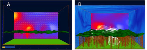
Research in integrated sensor networks and environmental modeling requires simulation and visualization tools able to capture key couplings and components, namely, sensors, platforms, embedded computing and communication systems, environments, targets, and algorithms associated with high-level tasks. Through the following requirements,
trainees contribute to the development of an integrated simulation, visualization, and data-analysis software package referred to as 3SVS. 3SVS is a modular software that allows users to design a sensor system, and related virtual experiments, by selecting the components from a suite of sensors, platforms, environments, and command-and-control modules. Subsequently, students interface selected modules and visualization software with the DiVE to produce an immersive, interactive experience and virtual rendering of a major research finding or field experiment.
Synthetic Sensor Simulation and Visualization Software (3SVS) Project
As part of the WISeNet Certificate and Program requirements, each trainee contributes new simulation modules to 3SVS, and then uses 3SVS to simulate, test, and validate the sensor system and algorithms developed in his/her dissertation and laboratory/field experiment. 3SVS will have three key capabilities: interactive visualization, data processing and analysis, and sensor data visualization. For the analysis of the data generated by 3SVS, students will build an indexing scheme, and develop a simple language to ask various queries on a database generated by the forest simulator. Trainees will also use such a package to visualize the data collection by the sensors and the data transmitted over the network. Trainees involved in computer science and engineering experiments can make use of the robotics freeware Player/Stage/Gazebo (PSG), which can be interfaced with other programming languages, such as Matlab® and C++, as well as of off-the-shelf visualization software such as USARSim.

Duke immersive Virtual Environment (DiVE) Project
